+51 984 387 050
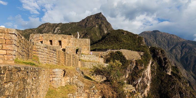
Machu Picchu (in Quechua – old Mountain), is the contemporary name given to a city (llaqta – ancient Inca town), built before the 15th century, located in the Eastern Cordillera of southern Peru, in the mountain range of the Andes, at 2430 masl. It is located in the Cusco region, Urubamba province, Machu Picchu district, 80 kilometers northwest of the city of Cusco, and where the Urubamba river flows, which crosses the mountain range and originates a canyon with a tropical mountain climate. According to current historians, its original name would be – Llaqtapata.
According to sixteenth century documents. Machu Picchu would have been one of the rest residences of Pachacútec throughout the entire empire, ninth Inca of Tahuantinsuyo between 1438 and 1470. However, according to its location and some of its best constructions show the ceremonial character of the llaqta, give an account of its origin before Pachacutec.
Machu Picchu is considered, at the same time, a masterpiece of architecture and engineering. Its peculiar architectural and landscape characteristics, and the veil of mystery that has woven around it much of the literature published on the site, have made it one of the most popular tourist destinations on the planet, as well as one of the new wonders of the world. world. Machu Picchu was declared a Peruvian Historical Sanctuary in 1981 and has been on the Unesco World Heritage List since 1983, under the name Historic Sanctuary of Machu Picchu. On July 7, 2007 Machu Picchu was declared one of the new seven wonders of the modern world
In 1865, in the course of his exploration trips through Peru, the Italian naturalist Antonio Raimondi passed unknowingly at the foot of the ruins and alluded to how sparsely populated the region was then. However, everything indicates that it is in those years when the area began to receive visits for interests other than merely scientific. Indeed a recently released investigation currently in progress reveals information about a German businessman named Augusto Berns who in 1867 would not only have “discovered” the ruins, but would have founded a “mining” company to exploit the alleged “treasures” they housed (the Anonymous Operating Company of the Huacas del Inca). According to this source, between 1867 and 1870 and with the permission of the José Balta government, the company would have operated in the area and then sold “everything it found” to European and North American collectors.
The archaeological zone is accessible, either from the post-Inca roads that reach it, or by using the Hiram Bingham road (which ascends the hill of Machu Picchu from the Puente Ruinas train station, located at the bottom of the canyon). Neither way exempts the visitor from the price of admission to the complex.
| Ruta | Nombre | Descripción | Días |
| 1 | km 82 | Pisqakucho-Kusichaca-Wayllabamba-Wiñaywayna-Machupicchu | 4 |
| 2 | km 88 | Qoriwayrachina-Wayllabamba-Wiñaywayna-Machupicchu | 4 |
| 3 |
Salkantay |
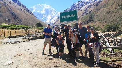
Mollepata-Soraypampa-Lluskumayu-Sta Teresa-Hidro-Aguas Calientes | 4 |
| 4 | km 82 | Pisqakucho-Qoriwayrachina-Papaymayu bajo-Chanchabamba-Wiñaywayna-Machupicchu | 4 |
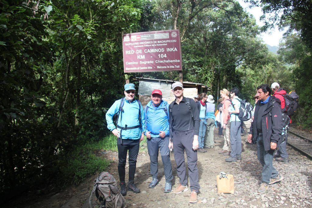
| 5 | km 104 | Chachabamba-Wiñaywayna-Machupicchu | 2 |
| 6 | Km 121 | Central Hidroeléctrica – santa teresa. | 2 |
PeruRail is one of the two railway companies authorized to offer transportation within the national park and to the town of Aguas Calientes.
The aforementioned highway, however, is not integrated into Peru’s national highway network. It is born in the town of Aguas Calientes, which in turn can only be accessed by rail (about three hours from Cuzco) 11 or by helicopter (30 minutes from Cuzco). The absence of a direct road to the Machu Picchu sanctuary is intentional and allows controlling the flow of visitors to the area, which, given its nature as a national reserve, is particularly sensitive to crowds. This, however, has not prevented the disorderly growth (criticized by the cultural authorities) of Aguas Calientes, which lives by and for tourism, since there are hotels and restaurants of different categories in this place.
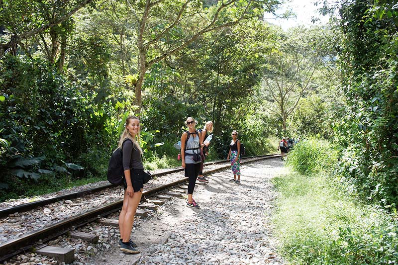
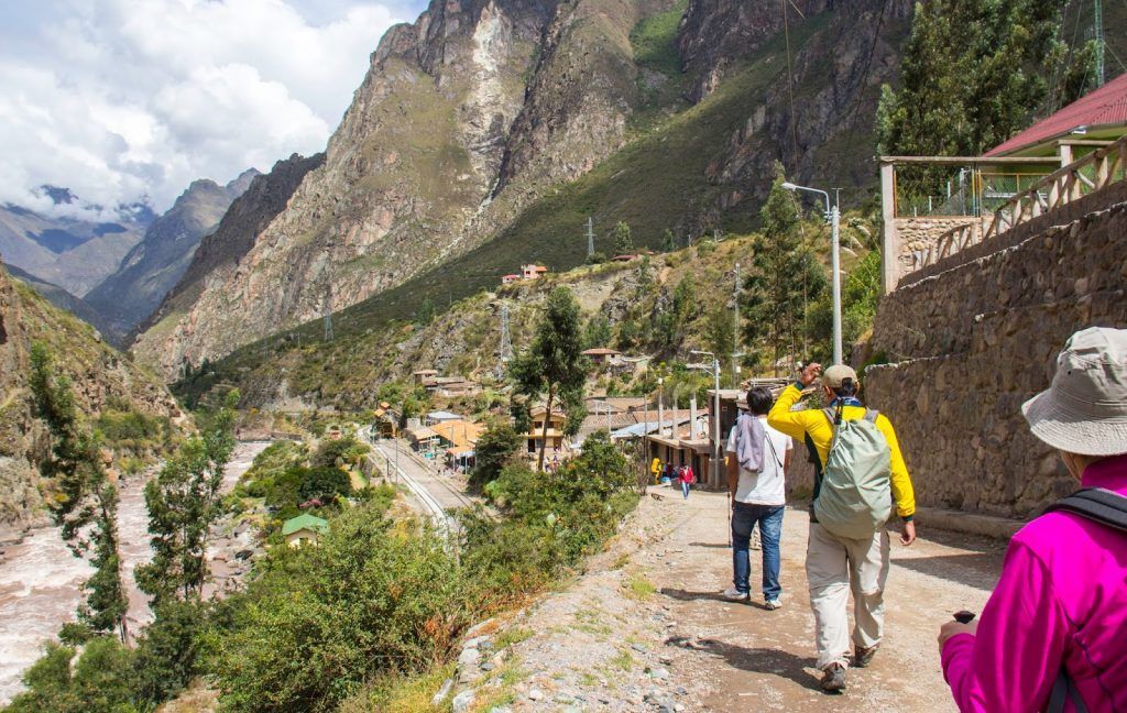
To get to Machu Picchu through the main Inca trail, you must walk for about three days. For this, it is necessary to take a train or bus to km 82 of the Cuzco-Aguas Calientes railway line, which coincides with the limit of the Machu Picchu national park, from where the route begins on foot.
Some visitors take a local bus from Cuzco to Ollantaytambo (via Urubamba) and from there take a transport to the aforementioned km 82. Once there, they travel the train tracks to cover the 32 km to Aguas Calientes. Currently, buses go to the Hydroelectric Plant located 9 km from Aguas Calientes, which takes approximately three hours on foot, which is the same path as the train.
The temperature is warm and humid during the day and cool at night. The temperature ranges between 12 and 24 degrees centigrade. The area in general is very rainy, especially between November and March. The rains, which are copious, alternate rapidly with moments of intense sun shine.
| Parámetros climáticos promedio de Machu Picchu | |||||||||||||
| Mes: | Ene. | Feb. | Mar. | Abr. | May. | Jun. | Jul. | Ago. | Sep. | Oct. | Nov. | Dic. | Anual |
| Temp. máx. media (°C) | 20 | 20 | 20 | 21 | 21 | 20 | 20 | 21 | 21 | 22 | 22 | 21 | 20.8 |
| Temp. media (°C) | 14 | 14 | 14 | 13.5 | 12.5 | 11 | 10.5 | 12 | 13 | 14.5 | 14.5 | 14.5 | 13.2 |
| Temp. mín. media (°C) | 8 | 8 | 8 | 6 | 4 | 2 | 1 | 3 | 5 | 7 | 7 | 8 | 5.6 |
| Precipitación total (mm) | 228 | 209 | 205 | 115 | 36 | 21 | 28 | 37 | 56 | 95 | 117 | 177 | 1324 |
| Días de precipitaciones (≥ ) | 18 | 14 | 15 | 6 | 3 | 3 | 3 | 3 | 5 | 9 | 11 | 16 | 106 |
| Humedad relativa (%) | 67 | 70 | 70 | 64 | 62 | 59 | 58 | 58 | 58 | 60 | 60 | 65 | 62.6 |
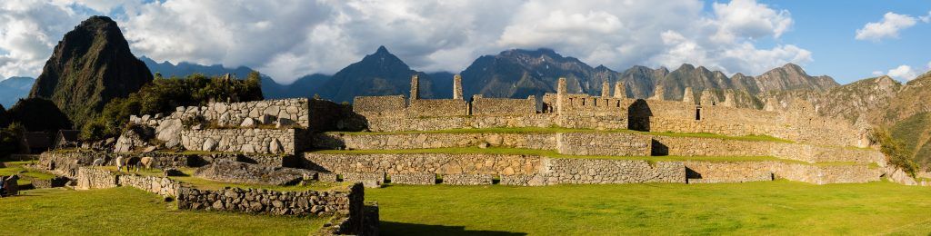
The area built in Machu Picchu is 530 meters long by 200 wide and includes at least 172 enclosures. The architectural complex is clearly divided into two areas: the agricultural area, made up of a set of terraces or cultivation terraces, perfectly designed and located in the mountains and located to the south of the city; and the urban area, the one where its occupants lived and where they carried out their main civil and religious activities. They are separated by a wall, a moat and a staircase.
The cultivation platforms of the Inca city of Machu Picchu look like great steps built on the hillside. They are stone structures and a filling of various layers of material between them (large stones, minor stones, gravel, clay and farmland) that facilitate drainage, preventing the water from becoming depleted and destroying the construction. This type of construction allowed it to be cultivated on them until the first decade of the 20th century. Other platforms of less width are found in the lower part of Machu Picchu, around the entire city. Its function was not agricultural but to serve as supporting walls.
A wall of about 400 meters long divides the Inca city from the agricultural area. Parallel to the wall runs a “moat” used as the main drainage of the city. At the top of the wall is the main entrance door to Machu Picchu inca city, that had an internal closing mechanism. The urban area has been divided by current archaeologists into groups of buildings. The scheme proposed by Chávez Ballón in 1961 that divides it into a Hanan sector (high) and another hurin (low) according to the traditional bipartition of society and the Andean hierarchy is still in force. The physical axis of this division is an elongated plaza, built on terraces at different levels according to the slope of the mountain.
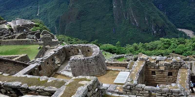
It is accessed by a double jamb cover, which remained closed almost all the time (there are remains of a security mechanism). The main building is known as “Torreón”, made of finely worked blocks. It was used for ceremonies related to the June solstice. One of its windows shows traces of having embedded ornaments that were torn off at some point in the history of Machu Picchu, destroying part of its structure. Also, there are traces of a large fire at the scene. The Tower is built on a large natural rock, below which is a small rock, which has been completely lined with fine masonry. It is believed that it was a mausoleum and that mummies rested in its large niches. Lumbreras even speculates that there are indications that he may have been the Pachacutec mausoleum and that his mummy was here until shortly after the Spanish invasion.
Of the buildings intended for housing, this is the finest, largest and best distributed. Its access door leads to the first fountain in the city. It includes two rooms with large monolithic lintels and well-carved stone walls. One of these rooms has access to a service room with a drainage channel. The set includes a pen for camelids and a private terrace with views of the east side of the city.
All the evidence indicates that the place was intended for different festive ceremonies and rituals. Connected to the Temple of the Three Windows, whose walls of large polygonal blocks were assembled like a puzzle, and the Main Temple, of more regular blocks, believed to have been the main ceremonial precinct of the city. Attached to the latter is the so-called “priest’s house” and the “chamber of ornaments”.
It is a natural formation, whose flanks were converted into terraces, taking the shape of a polygonal-based pyramid. It includes two long access stairs, to the north and south. At the top, there is the Intihuatana stone (‘where the Sun is tied’ also known as a sundial), one of the most studied objects in the Inca city of Machu Picchu, which has been related to a series of sacred places. from which clear alignments are established, between the surrounding mountains and astronomical aspects.
This is the name given to a flat face stone placed on perfectly worked stones. Representation of an Apu, or sacred mountain that surrounds the Inca city. Where the priests placed various offerings. It is also considered a landmark in the extreme north of the city and is the starting point of the road to Wayna Picchu.
It is a large architectural complex, dominated by three large courts arranged symmetrically and communicating with each other, something that could suggest that it was the Acllahuasi (or ‘house of chosen women’) of Machu Picchu, dedicated to religious service and fine craftsmanship. , of identical, they give to the main square of Machu Picchu. Includes homes and workshops.
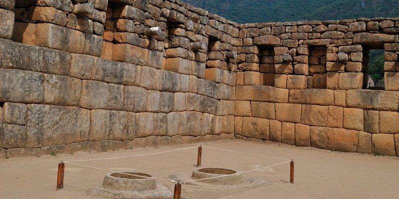
It is the largest complex in the city, despite which it only had one entrance door. It includes a famous well-carved stone room on whose floor are two rocky outcrops carved in the form of circular mortars supposedly for grinding grain. Some authors think that these were filled with water and the stars were reflected in them. The set includes evidence of a ritual use, there are altars and even a court built around a large rock. Possibly inhabited by people of hierarchy.
It is a wide set of constructions, where the contours of the rocks were used. Where caves with evidence of ritual use and a large stone carved in the center of a large courtyard, where the representation of a condor is observed. To the south of the “condor” are niches for ceremonial use. Clear remains of 2-level buildings have been identified between the houses and the patio of the condor, which fulfilled different functions.
It is a set formed by a large staircase next to which runs a system of water channels with 16 falls in fountains. The water comes from a spring in the heights of Cerro Machu Picchu that was channeled in the Inca era. At the top of the mountain there is an extraordinary system, collecting leaks from the rain and diverting them through a main channel to the city.
At the top, there is the main access door to the Inca city of Machu Picchu, superimposed rocks and perfectly worked, immediately after entering the street, there are six environments. These are rustic buildings that served as a home for the guardians of the main gate, as well as stonemasons, carvers or stonecutters, and farmers of the time. In excavations carried out, a large number of remains of household utensils have been found. Also in relation to this area, a number of very hard tools and stones were found.
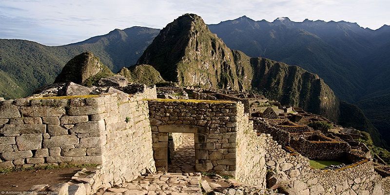
Well, the quarry is very close to this group. Place where the work was carried out on the rock, molded and fine finished. Originally, the entire area where the city of Machu Picchu settled was a large quarry, which today geologists call “the granite chaos”. The rocks, which were transformed into lithic polyhedra and transported to the site, are of different qualities. There they received the finish and the final carving. Polishing would take place after being placed on the facing.
